


Today
Storm Jorge will impact Ireland today, bringing extremely strong winds.
Cold to begin, with wintry showers.
Frost and some icy patches in places also. A band of heavy rain will soon extend from the west this morning, turning to sleet or snow in places, especially through the Midlands and north for a time, before turning back to rain later.
The sleet and snow in combination with strong winds will make driving conditions extremely hazardous in places this morning and early afternoon.
A clearance to showers of mostly rain and hail with a continuing risk of thunder will gradually follow from the southwest in the late afternoon and evening, though not reaching Ulster until tonight.
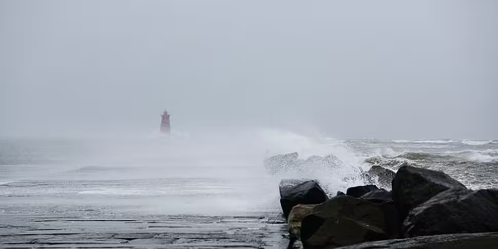
Extremely windy or stormy in all areas, with very strong southwesterly winds during the morning, veering westerly and strengthening further through the afternoon, with severe and damaging gusts.
Strong gale to storm force winds on all coasts with violent storm force winds on western coasts for a time this afternoon, with a risk of coastal flooding.
Cold, with maximum afternoon temperatures of just 5 to 7 degrees.
Tonight
The last of the rain will clear the north coast early tonight, with scattered showers following.
The showers will be most frequent over the western half of the country and some will be wintry over high ground.
Minimum temperatures zero to plus 3 degrees, with frost and icy patches. Coldest in the east where there will be long clear spells.
Westerly winds remaining strong early tonight with gales on coasts and strong gales on northern coasts. Winds decreasing gradually later tonight.
National weather warnings
There are eight weather warnings in place or due to be in place for the entire country.
A status red wind warning has been issued for Galway and Clare.
This will see very severe winds associated with Storm Jorge on Saturday.
Westerly winds will reach mean speeds of 85 to 100km/h in places on Saturday afternoon with gusts of 130 to 145km/h, with an elevated risk of coastal flooding.
The alert is in place from 11:00am to 3:00pm - people are advised to remain indoors during this time.
A status orange wind warning is in place for Galway, Mayo, Clare and Kerry from 6:00am Saturday to 3:00am Sunday.
Southwest quickly veering west and later northwest will reach mean speeds of 65 to 80km/h with gusts of 110 to 130km/h, possibly higher in very exposed areas with an elevated risk of coastal flooding.
There is a status orange wind warning also for Donegal, Leitrim and Sligo from 12:00pm Saturday to 3:00am Sunday.
Southwest quickly veering west and later northwest will reach mean speeds of 65 to 80km/h with gusts of 110 to 130km/h, possibly higher in very exposed areas with an elevated risk of coastal flooding.
A status orange wind warning is also in place for Leinster, Cavan, Monaghan, Roscommon, Cork, Limerick, Tipperary and Waterford.
Westerly winds will reach mean speeds of 65 to 80km/h for a time on Saturday afternoon and early evening with gusts of 110 to 120km/h, possibly higher in very exposed areas.
This is from 1:00pm to 7:00pm on Saturday.
A status yellow rainfall warning is also in place for Munster, Connacht and Donegal until midnight on Saturday.
Rainfall accumulations generally between 20 to 30mm expected during Friday and Saturday, but 40 to 50 mm possible in mountainous areas - with a continuing risk of flooding due to already saturated ground and elevated river levels.
While a status yellow snow/ice warning has been issued for Ireland until 4.00pm Saturday.
Wintry showers of hail, sleet and snow spreading eastwards this morning will lead to icy conditions.
Later this morning a more persistent band of rain and sleet will cross the country, turning to snow for a time, particular over the Midlands and north of the country, and over high ground elsewhere.
The combination of sleet/snow and strong winds will lead to low visibility and hazardous driving conditions.
A status yellow wind warning has been issued for Leinster, Cavan, Monaghan, Roscommon, Cork, Limerick, Tipperary and Waterford from 9.00am until 1.00pm on Saturday.
This will see southwesterly winds of mean speeds 50 to 65km/h on Saturday morning with gusts of 90 to 110km/h expected.
And there is a status yellow wind warning for Leinster, Cavan, Monaghan, Roscommon, Cork, Limerick, Tipperary and Waterford.
Westerly winds of mean speeds 50 to 65km/h on Saturday evening and early Saturday night with gusts of 90 to 110km/h expected.
This alert will be in place from 7:00pm until midnight on Saturday.


