


Gusts of up to 110 kilometers per hour are expected in parts of the country as Storm Dudley passes over Ireland.
A status yellow wind warning has been issued from midday Wednesday until 11.30pm.
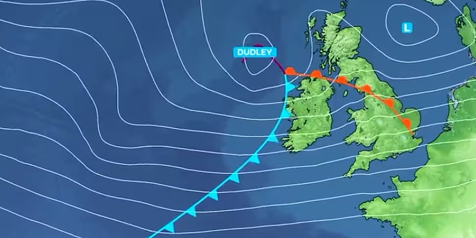
It says westerly winds will reach mean speeds of 50 to 65km/h, with damaging gusts of between 80 and 110km/h.
These will be stronger on exposed coasts and on high ground.
A combination of high tide and strong winds will lead to flooding on exposed coasts.
While a weather advisory says Storm Eunice will track eastwards over Ireland through Thursday night and Friday.
#StormDudley will arrive on Wednesday, followed by #StormEunice on Friday
Here is how they will develop over the next few days#TwoStorms pic.twitter.com/0kEFVSYIn7— Met Office (@metoffice) February 15, 2022
"It has the potential to be a multi-hazard and disruptive event with damaging winds, heavy rain and snow possible", Met Éireann says.
Current indications are that the strongest winds are most likely to affect southern counties, and the most significant falls of snow will be over central and northern parts.
Local blizzard conditions are possible for a time and could disrupt travel.
The forecaster says warnings will be issued and updated throughout Wednesday and Thursday.
Yellow and orange wind warnings are in place for Northern Ireland.
Meteorologist with Met Éireann, Andrew Doran-Sherlock, told Newstalk Breakfast people should be mindful if travelling.
"Winds are already picking up and they are going to increase today.
"The strongest winds will likely be in the west and the north-west - and there is high tide later today.
"With the combination of the two, you can see some wave over-topping causing some coastal flooding.
"Those winds will persist through the night, but they will start to ease then towards tomorrow morning".
He also says there is the potential for trees to come down.
"It's really just [to] be mindful of your surroundings, don't take any unnecessary risks and just to be careful - especially out travelling around".
And he says the rest of the week is looking pretty unsettled.
"Throughout the week we are experiencing breezy or windy conditions - we've got quite a strong jet positioned over us, so that's bringing in these stronger winds.
"We have the warning out for Storm Dudley and we have an advisory out for Storm Eunice for Thursday night into Friday.
"For the majority of the week ahead it is looking quite unsettled and breezy".


