


The Government is warning that Hurricane Lorenzo is likely to bring high seas and "very strong winds" later this week.
The Government's emergency taskforce met this evening as Met Éireann continues to closely monitor the hurricane's progress.
The forecaster has issued a weather advisory, warning of “very wet and potentially stormy conditions” over parts of Ireland on Thursday night and into Friday morning.
The National Emergency Co-ordination Group was convened at 4pm today to discuss preparations for the storm’s arrival.
Following the meeting the group warned members of the public to stay away from coastal areas with the storm expected to bring high seas.
Meanwhile very strong winds are expected to make driving conditions hazardous – especially for cyclists, pedestrians and high-sided vehicles.
Road users are being warned to look out for fallen trees and flying debris with trees still in full leaf.
The meeting of the National Emergency Coordination Group (NECG) to discuss preparations for #stormlorenzo has just commenced in the NECC with @MurphyEoghan @Damien_English @campaign4kehoe pic.twitter.com/nq9eL8blss
— Department of Housing, Local Government & Heritage (@DeptHousingIRL) October 1, 2019
Meanwhile, Met Éireann said it is on standby to issue weather warnings for certain areas.
The forecaster has warned there’s a “high probability” Lorenzo will track 'close to or over' Ireland on Thursday.
The National Emergency Co-Ordination Group brings together the likes of the OPW, Met Éireann, the Gardaí and Coast Guard to prepare a national response to emerging issues such as extreme weather.
Met Éireann has stressed it will not be a hurricane when it arrives on Thursday, but could bring high seas, severe winds and heavy rain.
The National Directorate for Fire and Emergency Management (NDFEM) has also been monitoring the track of the storm.
Lorenzo is a large and powerful hurricane, and its hurricane and tropical-storm-force wind fields are expected to expand further during the next few days.
It is moving north-north-eastward at 11 knots and the models generally agree that Lorenzo should pick up forward speed and move north-eastwards during the next day or two as a low pressure trough amplifies over the central Atlantic.
This flow should take the core of Lorenzo near or to the west of the western Azores late Tuesday and early Wednesday.
Evelyn Cusack is the head of forecasting at Met Éireann.
She says they are waiting to see how the storm develops before issuing a weather warning.
"So while it will give some very wet and very windy weather, perhaps Orange level warnings will be the worst - perhaps touching Status Red on the west and north-west coast.
"But we won't be issuing those warnings until Wednesday morning".
Evelyn Cusack of Met Eireann says they're on standby to issue weather warnings as Hurricane Lorenzo approaches.
By the time it reaches Ireland though, it's expected to have weakened to a tropical storm. #Lorenzo pic.twitter.com/stiKduxejD— Seán O'Regan (@SeanOR95) October 1, 2019
In Dublin, residents are being urged to use an online link to alert authorities to those sleeping rough during stormy weather.
The Dublin Region Homeless Executive says it's also working with outreach teams to make sure everyone who needs a bed during Hurricane Lorenzo gets one.
We have a facility for the public to report if they see a person sleeping rough in the Dublin Region. We cannot over emphasise how important your help is in locating people sleeping rough. So please let us know by using the link below. Thank you. https://t.co/iCmgvMSdby pic.twitter.com/C2tR932vrd
— Homeless Dublin (@HomelessDublin) April 20, 2018
Inner City Helping Homeless CEO Anthony Flynn said the city's local councils are not doing enough to protect rough sleepers.
He said 24-hour shelter must be put in place to protect people from the incoming storm.
"The minister can put in place with the stroke of a pen today if he wants to do so," he said.
"There are no extra units. Most people will be walking the streets up till 11pm tonight before they do get access to beds and many were put out at 7am this morning.
"It is completely unacceptable. We see this year-on-year when we have issues in regards to weather."
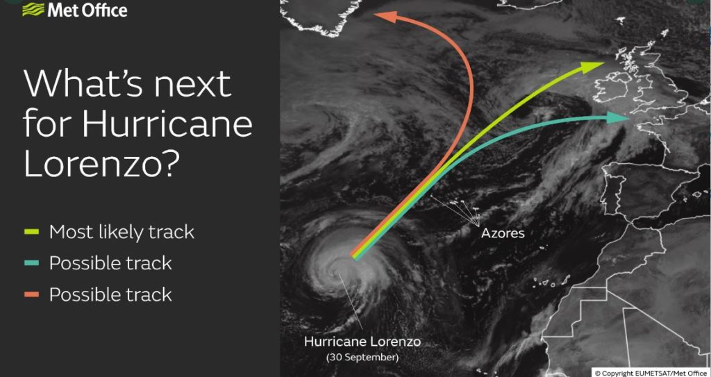 Image via @metoffice on Twitter
Met Éireann has been working with the US National Hurricane Centre, the EU and the UK Met Offices to forecast the evolution of Lorenzo.
The hurricane is forecast to transition to a tropical storm as it tracks towards Ireland, but its exact path is unknown.
The national picture is for winds to pick up on Wednesday evening, with rainfall and wind continuing throughout Thursday and into Friday morning.
The Office of Public Works (OPW) has confirmed that high seas and potential storm surges may occur along the coast as this system approaches Ireland.
The Department of Housing, Planning and Local Government has contacted all local authorities, requesting that they monitor Met Éireann's forecasts, and prepare for storm impacts by activating Crisis Management and Local Co-ordination arrangements.
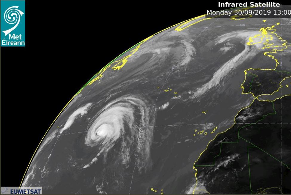 Image via @MetEireann on Twitter
It has also contacted the Department of Transport, An Garda Síochána, the ESB, the OPW and Irish Water.
Additional reporting Michael Staines


