


Today
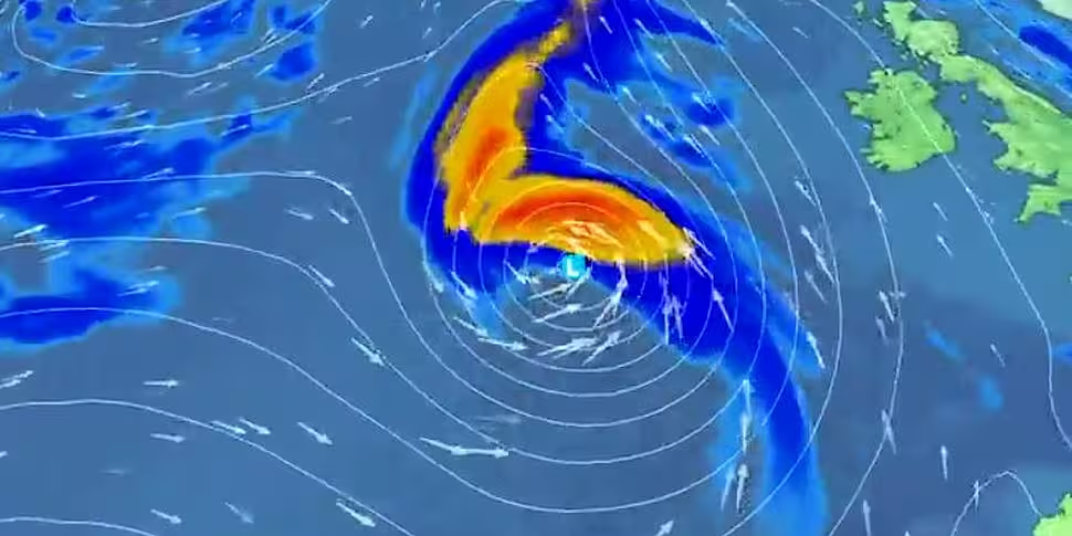
Turning wet and windy today as the outer rain-bands associated with Storm Lorenzo track across Ireland.
Southeast winds will be strong and gusty. Very high seas are expected along the Atlantic coast.
Highest temperatures of 15 to 19 degrees.
During the evening the centre of Storm Lorenzo will move closer to the northwest coast.
Southerly winds will veer west to southwest, with gales and possibly damaging gusts along Atlantic coasts.
Heavy rain will move into the west too.
Tonight
The centre of Lorenzo is expected to track across the country tonight.
On west coasts, westerly winds will reach gale to strong gale force with possibly damaging gusts combined with very high seas.
Further inland in Connacht, Munster and south Leinster, westerly winds will be strong overnight. In Ulster and north Leinster, winds will be lighter.
There will be heavy rain for a time, especially in the west, giving spot flooding there.
Lows of 8 to 11 degrees.
National weather warnings
A status orange wind warning has been issued for Galway, Mayo, Clare, Kerry and Limerick.
Southwesterly winds veering westerly will reach average speeds 65 to 80km/h, with gusts generally of 100 to 130km/h, higher in some coastal regions.
Storm surges will also produce coastal flooding and damage.
This is in place from 6.00am Thursday until 6.00am on Friday.
There is a status yellow wind warning for the rest of Ireland - with southeasterly winds later veering southwesterly, reaching mean speeds 50 to 65km/h with gusts to 100km/h resulting in "some disruptive impacts."
A status yellow rainfall warning is also in effect for Connacht, Leinster, Cavan, Monaghan and Donegal.
There will be spells of heavy rain at times today and tonight which will result in some flooding.
This alert is valid from Thursday at 9.00am to Friday at 6.00am.
And a separate status yellow wind warning is being issued for Wexford, Cork, Tipperary and Waterford from Thursday at 6:00pm until 6.00am on Friday.
Southwesterly winds could reach 65km/h with gusts of 90 to 100km/h.
Orange wind warning for #Lorenzo has been updated.
See warnings here https://t.co/oOxITrsnvw
Our meteorologist's commentary has also been updated
See here : https://t.co/gjN9OKdtdO#StormLorenzo pic.twitter.com/4RThUs71D9
— Met Éireann (@MetEireann) October 3, 2019
Weather advisory for Ireland
The effects of Storm Lorenzo will begin to be felt across Ireland from Thursday morning, easing Friday morning.
The main impacts will include disruptive winds, falling trees and flooding.
Met Éireann says: "In early October, trees are mostly in full leaf with a large surface area, so even moderate strength winds can bring down weakened trees and/or tree limbs.
"In addition, some trees may be compromised due to saturated soils at the moment, and with more rain forecast with Storm Lorenzo some disruption due to falling trees/branches is likely.
"Heavy rain, coupled with falling leaves may block drains and gullies, leading to surface flooding."
Coastal
Storm Lorenzo will produce significant swell, high waves and sizeable storm surges.
This will lead to wave overtopping, some coastal flooding and damage, especially along western and southern coasts.
Surface flooding
Saturated soils and the expected heavy/thundery rainfall may lead to surface flooding.
Rivers
River levels are currently elevated across the country and the rainfall may lead to river flooding, especially in parts of the midlands and west.
River levels will continue to rise after Storm Lorenzo has passed.


