


You may have experienced delays or route diversions as a result of a collision, as Gardai work to carry out investigations and map the entire scene. New technology is being used by the Traffic Division in Dublin and Cork, to speed up this process – halving the time it previously took to conduct this work. I went to Dublin Castle to find out more.
When Gardai arrive to the scene of an accident, they look to survey a scene and generate a picture of what exactly happened for the courts. Everything from the vehicles involved to the road signs and even low hanging trees must be documented.
I met with Sargent Ned Davin, one of the forensic collision investigators within the Traffic Division of Dublin Castle. He explained how the process, which Gardai use to do this has changed dramatically over the last 15 years.
"The technology has improved dramatically," he explains. "When we would travel to a scene before, the scene was using measuring tapes or measuring wheels. The correct way to measure out a scene is to set up a grid. So you would have a series of hundred meter tapes laid along the side of the road, and you measure out to locations at 90 degrees from that. Then you hand-drew a scale drawing of your scene. The first dedicated surveying equipment for collision investigators came in on issue in 2007."

That first equipment was called 'Robotic Total Stations' and helped cut down surveying time.
"We cut our surveying time in half, from the old system of measuring with tapes and wheels when we got the robotic total stations. Similarly, the new system that came in last year has cut that down even further - it's been cut down by more than half."
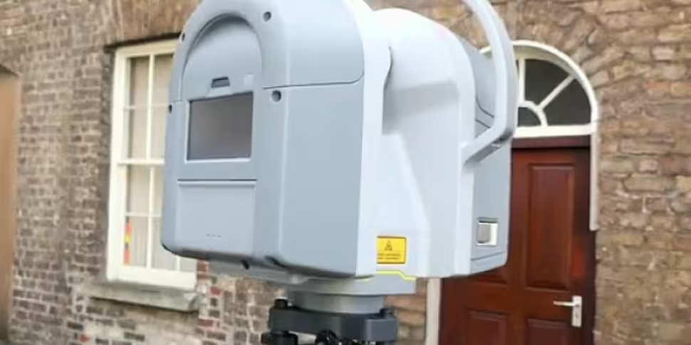
The new system Sgt Davin refers to is a 3D scanner. As of last year, Gardai in Cork and Dublin have been using this technology.

The scanner looks like a smaller projector that sits on a tripod. Gardai then place spheres at various locations around the collision site as focus points for the scanner, and it runs. The scanner turns 360 degrees and at an incredible rate to pick up every piece of detail.
Sgt Davin gave me an example of how the scanner has helped him in the past.
"There's a scene I went to back in 2008, which took me four hours to survey. Even at that, it wasn't finished. We wanted to keep the opposing carriageway open, so I had to come back the next day and survey the opposing side. All-in-all, that survey took me seven hours."
"The same location, for an incident last year in 2016, was surveyed in two hours using the 3D scanner. The volume of information gathered by the scanner was exponentially than any other method we had used up to the 3D scanner. This device can pick up 200 million points of reference on a scene."
Once the photos are captured, that information goes back to the Traffic Division to be analysed with a particular piece of software. This enables Gardai to measure and register every element of the site. I saw some test files and everything from the width of a car to the placing of a discarded soft drink bottle could be measured, logged and noted. The Gardai then create images for the court and make their investigations as to what exactly happened.
Rubbernecking
While the process for surveying sites using the 3D scanner is the same for every site, every collision is different. As Sgt Davin explained, there are varying factors. I asked him, however, how difficult it is to conduct the investigations on a road such as the M50 when you have multiple lanes and the prospect of causing huge delays.
"For the purposes of an investigation like that, first of all where there's confirmed fatalities or there is a strong possibility that this will result in a fatality or a life altering injury, there is a facility within the law to declare the area a crime scene. As a result, that section of roadway has to be shut down for examination. On a road like the M50, that is going to result in a lot of delays, particularly at peak times. The decision to close down a road is not taken lightly. There is a significant process involved."
"In one particular case in late 2015, evidence from a collision was spread right across the width of the road. Also, the road surface itself was heavily contaminated with fluids from the vehicles and there were heavy vehicles involved. For reasons of safety alone, the decision was taken to shut down that road. Emergency services working alongside live traffic is a hazard. You'll also have people who will want to stop to view the scene. On the occasion in question, a number of people were prosecuted for photographing the area from the opposing carriageway as they were driving along. That causes major problems on the opposing carriageway. You're dealing with an incident on one carriageway and then you have 'driver behaviour' on the other carriageway."


